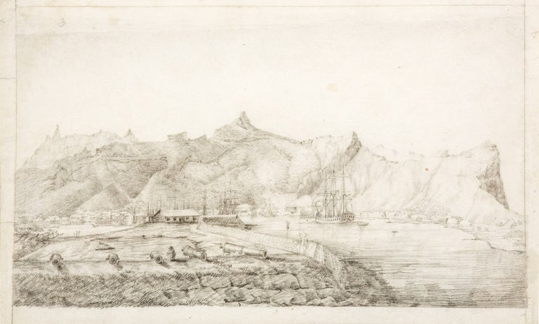
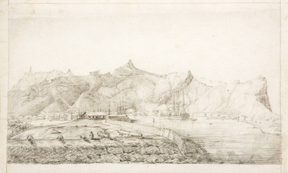
Original drawing of Port Louis from the Ile aux Tonneliers.
Port Louis (Mauritius): circa 1801.
Pencil drawing, 263 x 428 mm., fugitive note in pencil lower right; mounted.
The great Mauritian port in the age of Baudin and Flinders, with the Géographe at anchor
A fine pencil sketch of Port Louis, Mauritius, with the Géographe at the precise anchorage Baudin noted in his journal: any original depiction of the ship is an important discovery, let alone such a comprehensive view of this important harbour as the great explorers would have known it. In the foreground, ranged dramatically towards the viewer, are the cannons of the fort on the low-lying Ile aux Tonneliers, the man sketching between two of the guns presumably the artist himself. The background is dominated by the dramatic ridges of the mountains, while the foreshore is rendered in accurate detail, ranging from the Trou Fanfaron on the left to the open country beyond the slave encampments on the right. Charles-Alexandre Lesueur (1778-1846) was appointed to the Géographe because of his skills as a scientific artist: such was his ability that he and his great friend François Péron were appointed to publish the official voyage account, alongside Milbert who was in charge of the engravings.
A fine pencil sketch of Port Louis, Mauritius, with the Géographe at the precise anchorage Baudin noted in his journal: any original depiction of the ship is an important discovery, let alone such a comprehensive view of this important harbour as the great explorers would have known it. In the foreground, ranged dramatically towards the viewer, are the cannons of the fort on the low-lying Ile aux Tonneliers, the man sketching between two of the guns presumably the artist himself. The background is dominated by the dramatic ridges of the mountains, while the foreshore is rendered in accurate detail, ranging from the Trou Fanfaron on the left to the open country beyond the slave encampments on the right. Charles-Alexandre Lesueur (1778-1846) was appointed to the Géographe because of his skills as a scientific artist: such was his ability that he and his great friend François Péron were appointed to publish the official voyage account, alongside Milbert who was in charge of the engravings.
Although not signed, the view is based on a preliminary pencil study by Lesueur held in the museum at Le Havre, which has an identical perspective and includes all of the main features of the foreground, including the fort itself, the details of the ramparts and the Géographe ("suite de la vue prise à l'île aux tonnelliers [sic]", Baglione & Crémière, p. 52).
In fact, stylistically and technically the drawing appears to be a finished study for a never completed engraving: the style, shape and layout of the scene is closely in keeping with the two known plates which depict Timor and Port Jackson, both also after Lesueur, and both of which show the Géographe from an almost identical angle. It is certainly possible that the present scene was being considered for publication as the third of the three main European settlements visited on the expedition, but was ultimately abandoned: the torturous publishing history of the Baudin voyage makes such a hypothesis genuinely quite likely, not least because of the provenance.
Provenance: Baudin voyage artist Jacques-Gérard Milbert when he was in the USA (between 1815 and 1823): the view was in a small portfolio of works he gave to one of his students, which included at least one other Lesueur watercolour and several of Milbert's own important views. The entire portfolio remained with the family of the student, whose name is now recorded only as "Raschmann," until about 1990, when it was sold to an art dealer in California.
Gabrielle Baglione & Cédric Crémière, Charles-Alexandre Lesueur (Le Havre, 2009); Nicolas Baudin, The Journal of Post Captain Nicolas Baudin… Translated from the French by Christine Cornell (Adelaide, 1974); J.B.G.M. Bory de St. Vincent, Voyage to and Travels through the four principal islands of the African Seas… (London, 1805); Jean Fornasiero, Lindl Lawton & John West-Sooby (eds), The Art of Science (South Australia, 2016); Péron, François & Louis de Freycinet, Voyage de Découvertes aux Terres Australes… (Paris, 1807-1816).
Condition Report: A little browning and some light creasing to the paper (particularly noticeable on the margins), generally very good, the actual scene crisp and clear.
Price (AUD): $34,500.00
US$22,450.95 Other currencies