Carte Générale de l'Archipel des îles Mariannes…
[Paris]: [Chez Pillet Ainé], the map dated 1819, though known to have been published in 1826.
Large engraved chart on laid paper, 1030 x 710 mm., watermarked "Depot de la Marine", annotations in pencil and red ink (see note); a few creases, rather frayed and worn to the large margins, but a very good copy, unfolded as issued.
Freycinet's annotated map of the Marianas
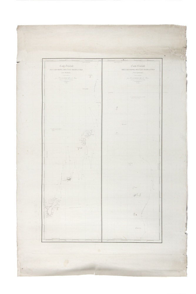
An important map from the personal archive of Louis de Freycinet, with distinctive annotations in his familiar style. Freycinet has gridded-up around most of the major landfalls on the map, a technique he used for added accuracy in the transfer of information and for further calculations. In the bottom left, adjacent to the island of Guam (the most significant island on the map and a major port of call for the Freycinet expedition), Freycinet has made some pencil calculations and remarks relating to the size of the island's landmass. Lastly, there is a series of repeated corrections turning the letter "u" into "w", in reference to the islands of Sariguan, Uracas, Aguigan, Guam, Almaguam and Guguan.
An important map from the personal archive of Louis de Freycinet, with distinctive annotations in his familiar style. Freycinet has gridded-up around most of the major landfalls on the map, a technique he used for added accuracy in the transfer of information and for further calculations. In the bottom left, adjacent to the island of Guam (the most significant island on the map and a major port of call for the Freycinet expedition), Freycinet has made some pencil calculations and remarks relating to the size of the island's landmass. Lastly, there is a series of repeated corrections turning the letter "u" into "w", in reference to the islands of Sariguan, Uracas, Aguigan, Guam, Almaguam and Guguan.
The map was published as no. 8 in the hydrographic atlas of the Freycinet expedition, but this example seems to have been separately issued by the "Depot de la Marine", referring to the French publisher of official nautical maps (not dissimilar to the British Admiralty), as a prominent watermark stating as much confirms. Given that Depot de la Marine maps are usually marked by a small printed device on the map itself, this unusual watermark suggests that this is may be a proof or early trial of the map, with the watermark functioning in much the same way that a digital watermark is used today. Adding to this supposition is the fact that the map has never been folded and has unusually large margins as one would expect with a map straight from the printer.
Duperrey is known to have made several of the maps published as part of the official account of the Uranie, and in fact, in a memorandum on his career he published in 1842, singled out his work on Guam for particular notice as regards its accuracy and significance (Notice sur les Travaux de Mr. L.I. Duperrey). Freycinet himself noted that the mapping of the region was done in unusually favourable conditions (Navigation et Hydrographie, p. 344).
Provenance: Originally from the sale of Freycinet family papers in the 1970s. The present owner acquired the map in the French booktrade.</p><p>
Price (AUD): $2,250.00
US$1,445.73 Other currencies