![Item #3002024 Hoc Volumine Continentur. Macrobii interpretatio in somnium Scipionis à Cicerone confictum. Eiusdem Satutnaliorum libri septem… [edited by Nicolaus Angelius]. Ambrosius Theodosius MACROBIUS.](https://hordern.cdn.bibliopolis.com/pictures/3002024.jpg?width=768&height=1000&fit=bounds&auto=webp&v=1698649082)
![Hoc Volumine Continentur. Macrobii interpretatio in somnium Scipionis à Cicerone confictum. Eiusdem Satutnaliorum libri septem… [edited by Nicolaus Angelius].](https://hordern.cdn.bibliopolis.com/pictures/3002024_01.jpg?auto=webp&v=1698649082)
![Hoc Volumine Continentur. Macrobii interpretatio in somnium Scipionis à Cicerone confictum. Eiusdem Satutnaliorum libri septem… [edited by Nicolaus Angelius].](https://hordern.cdn.bibliopolis.com/pictures/3002024_02.jpg?auto=webp&v=1698649082)
![Hoc Volumine Continentur. Macrobii interpretatio in somnium Scipionis à Cicerone confictum. Eiusdem Satutnaliorum libri septem… [edited by Nicolaus Angelius].](https://hordern.cdn.bibliopolis.com/pictures/3002024_03.jpg?auto=webp&v=1698649083)
Hoc Volumine Continentur… [Opera, edited by Nicolaus Angelius].
Hoc Volumine Continentur. Macrobii interpretatio in somnium Scipionis à Cicerone confictum. Eiusdem Satutnaliorum libri septem… [edited by Nicolaus Angelius].
Florence: Philippo di Giunta, 1515.
Octavo, ff. [xii], 280, italic letter, woodcut printer's device on last leaf, with six woodcuts; contemporary vellum.
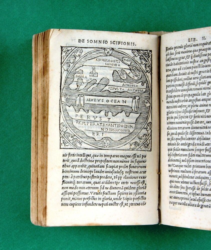
The pocket Macrobius, with the famous world map
The first popular pocket edition of Macrobius's influential text, printed by the Giunta family in Florence; such smaller format publications were a feature of publishing in the early sixteenth century and must have looked as startlingly modern then as Allen Lane's first Penguins looked in the 1930s or ´40s.
The first popular pocket edition of Macrobius's influential text, printed by the Giunta family in Florence; such smaller format publications were a feature of publishing in the early sixteenth century and must have looked as startlingly modern then as Allen Lane's first Penguins looked in the 1930s or ´40s.
This printing includes a slightly developed form of the famous Macrobian world map with its massive southern continent. One of the very earliest world maps, this half-page woodcut depicts a world split into two - Europe and the balancing Antipodes - and surrounded by ocean at the edges. This remarkable image, which survived by manuscript transmission from the fifth century into the age of printing, had a strong and lingering effect on post-Renaissance and pre-discovery geography. Carlos Sanz (El primer mapa del mundo…, Real Sociedad Geográfica, B 455, Madrid, 1966) has studied the significance of the maps with regard to Quirós and subsequent voyages of discovery into the southern hemisphere, while Beaglehole in his great edition of the journals of Cook has neatly written of 'the circular maps of another cycle, that of Macrobius… [who] goes rather further than Cicero or St. Isidore; for whereas Cicero thought the southern zone habitable, and St. Isidore noted that there 'the Antipodes are fabulously said to dwell', Macrobius considered that the heat of the torrid zone would forever keep men from providing any proof. There however is the neatly balanced round of the Macrobian map: in the middle the broad Bath of Ocean, bounded on either side by the wavy coastline of an insular continent, northern and southern, snugly fitted into the waters of its half-circle. Each is divided into three bands: the first, rather narrow, facing on the Alveus Oceani and labelled Perusta - 'burnt up'… So seductive, in the field of science, was harmony, symmetry, balance, the fitness of things; so difficult has it been for the geographer, as for other men, to wait on facts. So little, one is tempted cynically to add, has it mattered in the long run…' (Beaglehole, Journals, I, pp. xxv-vi ).
Adams, M59; Shirley, Mapping of the World, p. 12.
Condition Report: A bit stained, but a good copy.
Price (AUD): $4,850.00
US$3,108.35 Other currencies