Tabula Indiæ Orientalis…
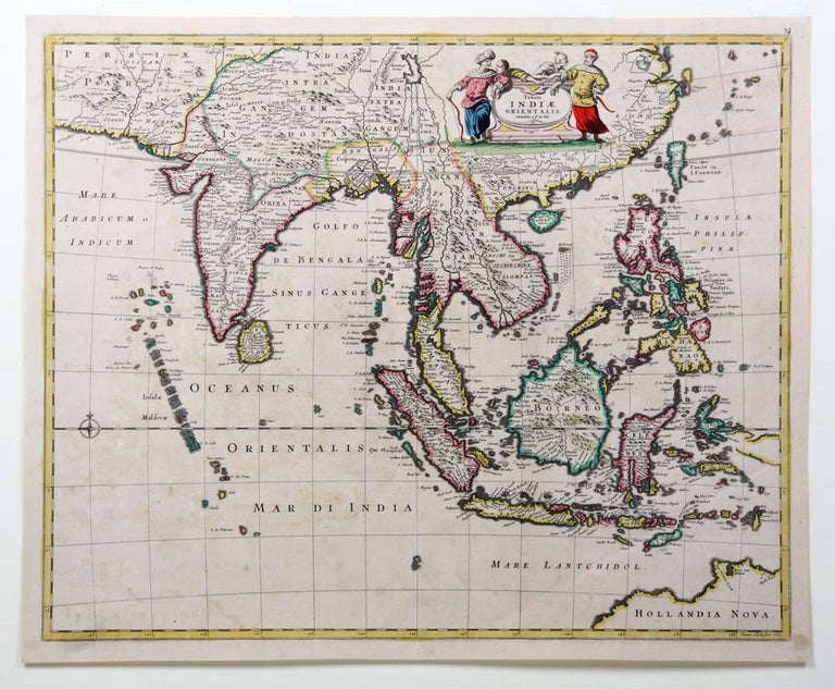
Tabula Indiæ Orientalis, emendata a F. de Wit.
Amsterdam: 1662.
Engraved map, 460 x 560 mm., with original handcolouring; mounted.
Tasman map by Blaeu's apprentice
Fine early map of the East Indies showing the north-Australian discoveries of Abel Tasman. Frederick de Wit was one of the foremost map-makers in Holland, whose 'maps were distinguished by their excellent craftsmanship, exactness and beauty…' (Schilder). This map stretches from Persia in the west to China and Taiwan in the east, and shows northern "Hollandia Nova", bearing three significant place names: "Van Diemens Landt"; "Baya van Diemen" and "Vuyle hoeck" (the last a disparaging term meaning something like "rotten corner" and evidently relating to the inhospitable coastline). These were among the names given to places on the north coast of Australia by Tasman during his voyages of 1642 and 1644 in the service of the Dutch East India Company.
Fine early map of the East Indies showing the north-Australian discoveries of Abel Tasman. Frederick de Wit was one of the foremost map-makers in Holland, whose 'maps were distinguished by their excellent craftsmanship, exactness and beauty…' (Schilder). This map stretches from Persia in the west to China and Taiwan in the east, and shows northern "Hollandia Nova", bearing three significant place names: "Van Diemens Landt"; "Baya van Diemen" and "Vuyle hoeck" (the last a disparaging term meaning something like "rotten corner" and evidently relating to the inhospitable coastline). These were among the names given to places on the north coast of Australia by Tasman during his voyages of 1642 and 1644 in the service of the Dutch East India Company.
'Frederick de Wit, an apprentice of William Blaeu… became one of the most prominent and successful map engravers and publishers in Amsterdam following the decline of the Blaeu and Jansson establishments. His work, notable for the beauty of the engraving and colouring, was very popular and editions were issued many years after his death…' (Parry, The Cartography of the East Indian Oceans, p. 118). Engraved by Johannes Lhuilier this map is coloured in outline and decorated with a cartouche showing four dramatically-posed and exotic costumed figures of the East.
Not in Tooley; Parry, The Cartography of the East Indian Islands, p.118 and plate 4.28.
Condition Report: Fine condition.
Price (AUD): $2,250.00
US$1,445.73 Other currencies